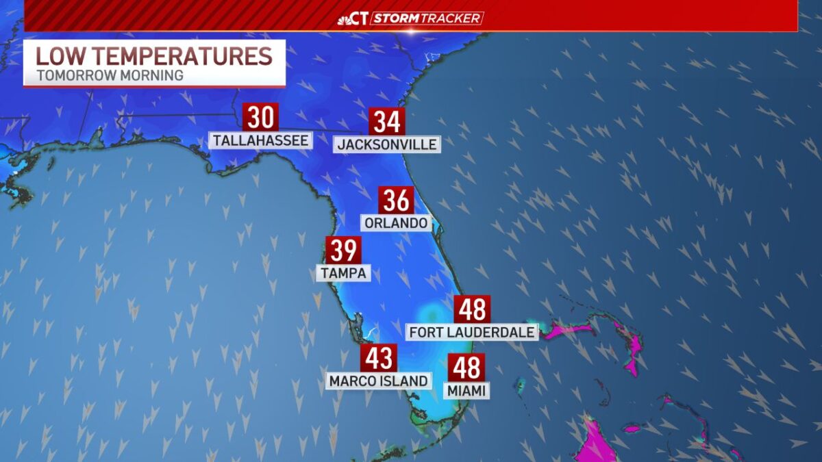
Central Florida is under an official Freeze Warning for New Year’s Eve into early New Year’s Day, with temperatures expected to dip at or below the freezing point (≤32 °F/0 °C) in inland communities overnight — a rare and impactful cold-air event for this region. Multiple counties north and northwest of Orlando are specifically highlighted by the National Weather Service (NWS) for sub-freezing lows early Wednesday morning, with wind chills reaching the 20s, prompting safety advisories for people, pets, plants, and infrastructure.
Why This Matters
A Freeze Warning Central Florida means actual freezing temperatures are forecast, not just a cold front or chilly night. Unlike a Freeze Watch (which signals potential), the warning confirms that temperatures will reach freezing or below — a significant concern in a region where such lows can damage outdoor plumbing, kill tender vegetation (like citrus and tropical ornamentals), and pose health risks without proper precautions.
What the Weather Forecast Is Telling Us
The Cold Front & Temperatures Expected
Central Florida is being hit by a strong cold front moving southeastward across the peninsula. This surge of Arctic-derived air will transform a typically mild Florida winter night into one with:
- Lows in the 20s and 30s (°F) across vast swathes of inland Central Florida.
- Wind chill values in the 20s, making it feel colder than the air temperature alone.
- Evening temperatures on New Year’s Eve in the 30s and lower 40s, with highs struggling to break into the 50s.
Orlando and its surrounding neighborhoods will feel like a completely different climate compared to recent weeks, especially overnight.
H2: What a Freeze Warning Central Florida Actually Means
Official NWS Criteria
A Freeze Warning is issued when widespread sub-freezing temperatures (≤ 32 °F/0 °C) are expected — typically for several hours overnight. In Florida, this can be especially impactful because:
- Many homes and small businesses lack insulation meant for prolonged freezing.
- Outdoor plants and crops (including citrus) are vulnerable to freeze damage.
- Unprepared residents may underestimate the risk in a region that rarely sees such lows.
From a meteorological standpoint, this is the real deal — not a mild cool-down. When the NWS warns of freeze conditions, they anticipate temperatures cold enough to cause frost and freeze damage.
Counties Under Freeze Warnings and Advisories
While specific county lists may shift slightly as conditions evolve, central portions of the region covered include:
- Volusia County (north of Orlando)
- Lake County
- Sumter County
- Portions of Marion County further inland
In addition, Cold Weather Advisories extend more broadly across Central Florida — including Orange, Osceola, Seminole, Brevard, and more, where wind chills are expected to be severe even if readings stay just above freezing.
When the Freeze Warning Is in Effect
According to the official alerts:
- Effective: From late Tuesday night (Dec 30)
- Through: Wednesday morning (Dec 31), typically until around 9 a.m. EST
- This covers the earliest hours of New Year’s Eve morning when the cold is most intense.
It’s precisely this overnight window — with clear skies and light winds — that allows temperatures to plummet rapidly after sunset.
Real-World Impacts You Should Know
Health & Safety Risks
Unlike typical warmth Floridians are used to, the upcoming conditions present genuine risks:
- Hypothermia & frostbite are possible if people are exposed for extended periods without proper clothing.
- Wind chill effects make it feel significantly colder than the thermostat reading alone.
- Unprepared residents may underestimate the danger because the region rarely sees sustained freezing.
If you’re planning New Year’s celebrations outdoors or have pets outside overnight, this is not the night to cut corners.
Vegetation, Agriculture & Outdoor Plants
Florida’s signature citrus groves and ornamental gardens are extremely sensitive to extended freezing:
- Freeze damage and frost can kill blossoms, leaves, and fruit on citrus trees.
- Sensitive ornamentals like hibiscus and bougainvillea can outright die if exposed.
- Gardeners in Central Florida often rush to cover plants or bring potted specimens indoors on nights like these.
This isn’t hypothetical — freezes in Central Florida historically have devastated crops and landscape plants when residents are not prepared.
Infrastructure & Plumbing Concerns
Many Central Florida homes do not have frost-protected plumbing:
- Extended sub-freezing can cause pipes to freeze and burst, leading to costly repairs.
- Outdoor sprinkler systems, pool equipment, and irrigation lines are all vulnerable.
- Residents are being urged to drip faucets, insulate pipes, or drain exposed systems ahead of the freeze.
Safety Tips (Evidence-Backed & Practical)
Floridians may be less accustomed to deep cold, so here’s precisely what local emergency management and NWS guidance suggest:
- Dress in Layers: Thermal base layers, insulated jackets, hats, gloves — even in Florida.
- Bring Pets Inside: Animals left outdoors are at risk of hypothermia.
- Protect Plants: Cover with frost cloths or blankets; bring potted plants indoors.
- Prevent Frozen Pipes: Wrap or insulate exposed pipes; let faucets drip slightly overnight.
- Check on Neighbors: Elderly individuals are especially vulnerable.
These aren’t just tips — they align with official recommendations linked to Freeze Warnings and Cold Weather Advisories.
When the Cold Eases and What’s Next
Good news: This cold snap is relatively brief:
- Models show temperatures rebounding later this week with highs returning to the 60s and even into the 70s by the weekend.
- Winds will ease once the front pushes offshore.
- The risk of another widespread freeze in the near term is low based on current forecasts.
But the key message remains: tonight matters for safety and property protection.
Conclusion: A Historical but Manageable Freeze Event
From my years covering weather impacts across diverse climates, this forecast stands out for one simple reason: freezes in Central Florida are neither routine nor to be taken lightly. Most years might see the occasional cool night, but official Freeze Warnings mean the mercury is actually expected to hit or drop below 32 °F — a threshold that, if ignored, leads to plant loss, infrastructure headaches, and unnecessary health risk.
For residents and visitors alike, the message is clear: prepare tonight, protect what matters, and expect a brisk New Year’s morning. The deeper warmth of 2026 will resume soon, but this cold spell demands respect and preparation.