Charlotte Weather: Sleet Transitioning to Freezing Rain – Ice, Warnings & What to Expect Sunday–Monday
A powerful Winter Storm in North Carolina is arriving this weekend, with the National Weather Service (NWS) issuing Ice Storm Warnings and Winter Storm Warnings across central and western parts of the state. Sleet is expected to begin Saturday evening in Charlotte and then transition to freezing rain on Sunday, with ice accumulations potentially between 0.25 and 0.75 inches, creating hazardous travel, power outage risks, and extended below-freezing conditions into Monday.
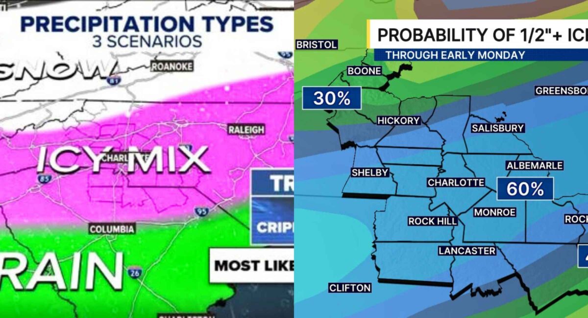
What’s Happening Now: Storm Overview & Alerts
Storm energy from a broad weather system — often being tagged as “Winter Storm Fern” in media outlets — is spreading eastward across the U.S., bringing freezing precipitation, snow, sleet, and ice from the Plains into the Southeast and Carolinas. A Winter Storm Warning and Ice Storm Warning are in effect for much of North Carolina, particularly for the Charlotte area and central Piedmont.
- Ice Storm Warning: In effect for much of the Charlotte region — the first such warning in over two decades — indicating significant ice accumulation forecast.
- Winter Storm Warnings: Issued for outlying counties in western and northern North Carolina as precipitation begins Saturday night and continues through Sunday.
- State of Emergency: Declared across parts of central North Carolina as officials prepare resources, route treatments, and emergency responses.
Storm travel impacts and ice risk are high through Monday afternoon before conditions begin to slowly improve.
Storm Timeline: When It Will Hit
Saturday (Jan 24, 2026)
- Late Afternoon / Evening: Temperatures fall toward freezing, especially after sunset.
- Precipitation Begins: Sleet and possibly light snow in some northern/western sectors; sleet likely mixes with ice.
Sunday (Jan 25, 2026)
- Freezing Rain Takes Over: Sleet transitions into more widespread freezing rain — the most dangerous phase.
- Ice Builds Quickly: Ice accumulation forecast of at least 0.25–0.75″ or more in some areas.
Monday (Jan 26, 2026)
- Lingering Cold, Continued Ice Hazards: Still below freezing in many counties; any remaining ice won’t melt easily, sustaining travel and power outage threats.
Forecast: Snow, Sleet & Ice Totals
Statewide guidance from NWS and local meteorologists shows the mix and amounts varying by terrain:
Piedmont / Charlotte Region
- Sleet: ~1–2″ possible
- Ice: ~0.25–0.50″ and possibly up to ~0.75″ near I-85 corridors
- Snow: Light amounts possible — especially northwest of Charlotte — but ice will dominate.
Foothills & Western NC
- Sleet and light snow totals could be higher (3–6″ in elevated areas).
These totals are not set in stone — temperature profiles above ground will heavily influence whether precipitation falls as sleet, freezing rain, or snow. However, ice remains the biggest concern (especially for power lines and roads).
Why Freezing Rain Is So Dangerous
Unlike light snow, freezing rain forms a glaze of ice on exposed surfaces:
- Roadways & Bridges: Even a thin layer of ice turns streets into skating rinks — especially in a region like central North Carolina, where winter road treatment infrastructure is limited compared with northern states.
- Power Lines & Trees: Ice accretion weighing down lines and limbs can cause outages lasting days if storms are prolonged.
- Travel: Multiple agencies are urging residents to stay off roads if possible through Sunday into Monday.
It doesn’t take much ice to disrupt daily life — as little as ¼″ can break branches and knock out power.
Regional Alerts & Official Warnings
National Weather Service (NWS) Alerts
- Ice Storm Warning: Charlotte metro and surrounding central NC counties through Monday afternoon.
- Winter Storm Warning: Western and northern areas, including Ashe and Watauga counties.
- Winter Storm Watch: For other counties awaiting possible upgrade as precipitation nears.
State Preparedness
- State of Emergency: Declared by Gov. Josh Stein to enable resource mobilization (crews, power companies, emergency services).
- DOT and Local Agencies: Pre-treating roads with brine and moving equipment into position before the storm’s peak.
Impact on Everyday Life
Travel & Road Safety
Hazardous roads — especially overpasses, bridges, and rural stretches — may become impassable at the peak of freezing rain. Authorities are advising:
- Avoid unnecessary travel Saturday night through Monday
- Expect delays and closures
- Public transit may have interruptions
Power Outage Risks
Utility companies are staging crews across the state given ice loading on power infrastructure. Extended outages remain a possibility.
Schools & Businesses
Closures and remote arrangements are likely for Monday depending on snow/ice severity and road conditions.
Air & Rail Travel
Major winter systems are already disrupting air travel nationwide, including at Charlotte hubs — passengers are urged to check with carriers.
How to Prepare (Essential Tips)
Before the Storm
- Stock up on food, water, medicines, batteries, and blankets.
- Ensure vehicles have winter kits and full gas tanks.
- Charge devices and have backup power options.
During the Storm
- Stay home if possible.
- Avoid walking on ice-coated paths.
- Keep faucets slowly dripping to prevent frozen pipes.
After the Storm
- Use extreme caution on roads, even as temperatures climb above freezing briefly.
- Watch for downed power lines and report outages promptly.
Why This Storm Matters
From personal observation of past Carolinas ice events (for example, the rare 2002 Charlotte ice storm that left neighborhoods in the dark for days), even modest ice storms pack outsized impacts here. Unlike traditional snowstorms, ice doesn’t melt quickly — and the region isn’t as equipped to treat roadways compared with colder states.
This event also underscores how a major winter storm — even one not heavily snowy — can still disrupt travel, utilities, schools, and daily routines when freezing rain dominates.
Conclusion & Forward Outlook
Winter Storm North Carolina is unfolding as a significant ice and sleet event, with Charlotte and central portions of the state bracing for hazardous conditions Sunday through Monday. Ice accretions of up to three-quarters of an inch combined with persistent below-freezing temperatures will challenge travel, threaten power infrastructure, and keep communities on alert into early next week.
Given the highly dynamic nature of precipitation types and the storm’s evolution, residents should stay updated with official NWS forecasts, heed travel advisories, and prepare for ice hazards through Monday. The real test of this storm won’t be snow amounts — it will be how resilient infrastructure and daily life hold up under prolonged ice and cold.