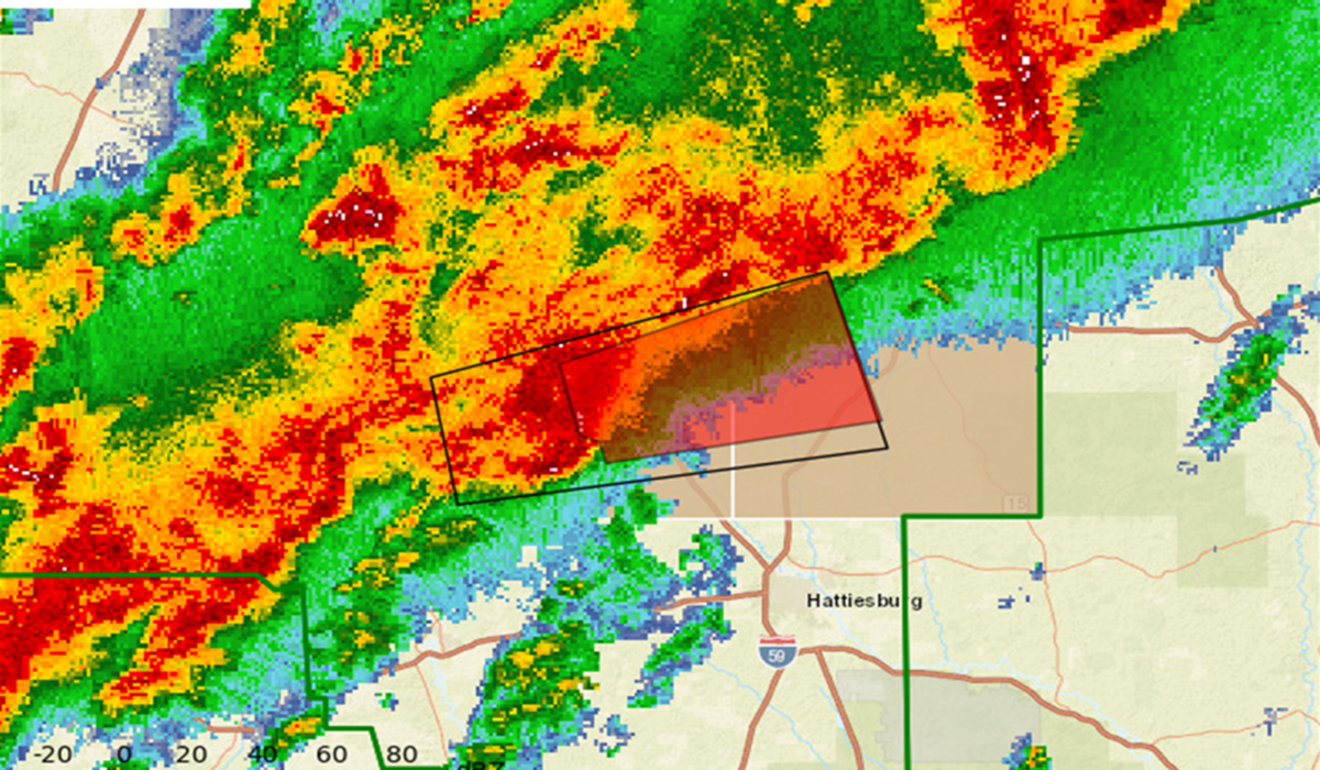
A potent and rapidly evolving severe weather system has brought multiple tornado warnings across the central and southern United States, with confirmed tornadoes in Oklahoma and Mississippi and a continued threat of severe storms and tornadoes for the Gulf Coast on January 10, 2026. The National Weather Service and local storm offices have been actively issuing alerts as powerful thunderstorms associated with a deep upper-level disturbance interact with warm, moist Gulf air, creating an environment ripe for damaging winds, heavy rain, and rotating storm cells capable of producing tornadoes. Across Mississippi early January 9, radar confirmed at least two tornadoes on the ground, prompting urgent warnings for multiple counties, including Leake, Madison and Jefferson Davis, where residents were urged to seek immediate shelter as storms approached.
In Oklahoma, severe thunderstorm activity on January 8 and into January 9 produced four preliminary tornadoes, with the National Weather Service confirming multiple twisters — including an EF1 near Purcell and additional touchdowns near Shawnee and Lake Thunderbird — causing structural damage and power outages but, thankfully, no major injuries reported. State weather officials noted that this level of January tornado activity is unusual, with the recent spate bringing the state close to nearly breaking its historical monthly record for January tornadoes.
Meteorologists track this severe setup as part of back-to-back storm systems advancing eastward from the Plains into the Deep South and Gulf Coast, maintaining heavy rainfall and instability across the region. These systems are forecast to bring internally generated storm clusters capable of severe thunderstorm gusts, flash flooding, and embedded tornadic activity through January 10, with the threat extending from coastal Louisiana and Mississippi into Alabama and the wider Gulf Coast.
Summary: A powerful late-season storm system has already produced confirmed tornadoes in Mississippi and Oklahoma and continues to pose severe weather threats — including tornado warnings — for parts of the Gulf Coast on January 10, 2026. Meteorologists forecast ongoing thunderstorms with the potential for damaging winds, heavy rain and isolated tornado activity as the complex moves eastward. Residents along the Gulf and Deep South should remain vigilant and prepared for rapidly changing conditions.
Severe Weather Dynamics: Early Tornadoes and Ongoing Warnings
The severe weather pattern unfolded rapidly over the past 48 hours. In Mississippi, emergency alerts were activated on the morning of January 9 as rotating storm cells moved through central and southern parts of the state. Radar data confirmed that multiple tornadoes were on the ground, with one storm cell observed moving eastward near Thomastown at about 30 mph, threatening small towns and rural communities with dangerous debris and possible structural damage. Several counties remained under Tornado Warning status into the day, with officials emphasizing the heightened risk to mobile homes, vehicles and unreinforced structures.
Across Oklahoma, the mid-week severe weather marked the first significant tornado outbreak of 2026. The National Weather Service reported multiple confirmed twisters on January 8, predominantly rated EF0 and EF1, affecting areas such as Purcell and Cleveland County. While structural damage was evident — including downed power lines and overturned vehicles — emergency management credited proactive warnings with helping avoid serious injuries. The increased frequency of early-season tornadoes in Oklahoma has stirred concern among climatologists, who note that while January tornadoes aren’t unprecedented, the clustering of events in early 2026 is notable.
Forecast models indicate that supercell development could continue into January 10 as a stationary front and abundant Gulf moisture provide the fuel for further severe thunderstorms. This weather setup also aids the potential for additional tornado watches and warnings, particularly where strong wind shear and atmospheric instability overlap.
Gulf Coast Threat and Broader Outlook
As the storm complex shifts eastward on January 10, weather services have flagged elevated severe risk for parts of the Gulf Coast and lower Southeast, including coastal sections of Louisiana, Mississippi and Alabama. The combination of warm, humid air over the Gulf and an approaching cold front is expected to support organized storm clusters capable of producing damaging wind gusts, heavy rainfall and isolated tornadoes throughout the day. Regions south of the front may see scattered thunderstorm activity alongside notable rainfall totals, which could exacerbate flash flooding in low-lying and urban areas
Local weather offices emphasize continuous monitoring of storm progressions and issuance of real-time warnings as conditions evolve. Residents within alert zones are urged to stay informed through NOAA Weather Radio, official NWS updates and local emergency alerts, maintaining access to safe shelter and a plan should tornado warnings be issued for their immediate location.