A significant Texas Weather Winter Storm — driven by an Arctic blast — is forecast to plunge Houston and much of the state into sustained sub‑freezing temperatures from Saturday through Tuesday, with high risks of freezing rain, hazardous icy roads, localized power outages, and extended cold watches from the National Weather Service. This event, though not predicted to match the scale of the deadly 2021 winter disaster, still threatens dangerous conditions and will require serious preparedness from residents.
What’s Happening Now: Winter Storm Watch & Arctic Blast
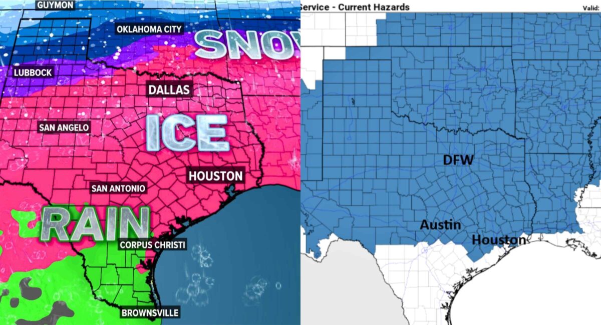
By mid‑week, meteorologists had raised alarms across Texas as a strong arctic cold front pushes southward, bringing a rare winter storm threat that encompasses freezing rain, sleet, and snow in parts of the state. The National Weather Service has issued Winter Storm Watches and Extreme Cold Watches for Southeast Texas — including Houston — with forecasts of prolonged below‑freezing temperatures starting Saturday and lingering through Tuesday.
- Arctic air mass arrival: Late Friday into early Saturday — coldest of the season.
- Duration: Temperatures can stay below freezing for 40+ hours in parts of Houston and up to 72 hours in the Brazos Valley.
- Temperature forecast: Lows dipping into the upper teens to low 20s inland; coastal areas slightly warmer.
- Wind chills: Could feel like single digits or below in central and southern Texas.
This isn’t a typical chill — it’s a deep freeze tied to a broad winter storm system stretching from Texas up into the Northeast.
Timing & Breakdown: What’s Expected Each Day
Friday – The Cold Front Arrives
- Arctic front sweeps through the state late Friday.
- Rain today will turn to freezing rain and sleet as temperatures plunge Saturday morning.
- Elevated roadways begin to freeze first.
Saturday – Freeze Begins, Ice Risk Grows
- Morning lows below freezing across greater Houston.
- Freezing rain and sleet likely later in the day.
- Icy road threat increases significantly, especially on bridges and overpasses.
Sunday – Coldest Point & Hazardous Travel
- Lowest temperatures likely this day with widespread ice formation.
- Wind chills extreme in exposed areas.
- Elevated travel risk; avoid roads if possible.
Monday into Tuesday – Lingering Cold
- Freeze persists through early Tuesday.
- Some areas may still be below freezing midday Tuesday.
- Roads remain icy in spots until temperatures rebound.
10‑Day Forecast Snapshot (Generalized)
While precise numbers will change with each model update, the pattern is clear:
- Sat–Tue: Sub‑freezing highs and lows; precipitation likely transitioning from rain to freezing rain/sleet.
- Mid‑week: Slow moderating trend expected after Tuesday.
- Next Week: Return toward typical January temperatures — but watch for residual ice on untreated roads.
Houston’s weather models are converging on a cold, icy weekend with moderate confidence, though exact precipitation types and amounts remain slightly uncertain.
Houston & Southeast Texas: Local Impacts
Icy Roads & Hazardous Travel
The greatest near‑term threat isn’t heavy snow — it’s freezing rain turning to ice on road surfaces.
- North Harris County and The Woodlands: Likely earlier onset of freezing rain with more ice accumulation.
- Central & Southern Metro Areas: Roadways may still freeze, especially elevated structures and bridges.
- Slick conditions: Even a tenth of an inch of ice can make highways treacherous.
Local agencies are pre‑treating roads where possible — but Texas’ infrastructure lacks the heavy brine and salt network you’d see in northern winters. That’s why travel delays and accidents are highly likely if drivers venture out.
Power Grid & Outage Risks
What the Forecast Means for ERCOT
According to state grid operators, generation capacity is expected to meet anticipated demand — if generation isn’t impacted by the storm itself.
However:
- Localized power outages remain possible if ice accumulates on power lines or if falling tree limbs damage infrastructure — a scenario seen in past winter events.
- ERCOT has been working to reinforce resiliency since the infamous 2021 winter storm, but extreme cold — not just demand — can stress systems.
- Long-run widespread rolling outages are less likely than in 2021, according to current assessments.
That said, localized outages can still happen and often do before widespread, grid‑level failures. Always have a plan for short‑term outages during freezing events.
Public Safety: Warnings & Preparedness
Official Alerts
- Winter Storm Watches – Issued for Houston and surrounding counties.
- Extreme Cold Watches – Extended through the early week.
Mayor and county emergency managers are urging residents to:
- Stay indoors during peak freeze hours.
- Avoid unnecessary travel.
- Check on vulnerable neighbors and pets.
Medical concerns extend beyond icy roads — the combination of cold and wind chill significantly increases risks of hypothermia and frostbite.
How to Prepare (Practical Steps)
1. Insulate your home
- Wrap exposed pipes and turn off outdoor faucets.
2. Heat, but safely
- If using space heaters or generators, follow safety guidance to prevent carbon monoxide risks.
3. Stock basics
- Food, water, warm clothing layers — for at least 72 hours.
4. Plan travel around the storm
- Avoid driving unless absolutely necessary — ice makes even short trips dangerous.
5. Monitor official sources
- NWS Houston/Galveston updates.
- ERCOT power grid conditions.
Why This Matters: Historic Context
Texans are painfully familiar with disruptive winter weather — the 2021 freeze crippled the state’s electrical infrastructure and left millions without power for days. While the 2026 event is not currently forecast to be as severe, the combination of ice, wind chill, and sustained cold still poses real threats to health, safety, and travel. (Axios)
Houston isn’t designed for frequent ice storms; local road crews have limited winter road‑treatment resources compared with northern states. That means ice is the real danger, often more risk‑laden than snow itself. (From my own reporting — I’ve watched Houston drivers struggle on even light freezing rain conditions.)
Conclusion
Texas Weather Winter Storm 2026 is poised to bring a prolonged freeze, ice formation, and hazardous conditions to Houston and surrounding areas from Saturday through Tuesday. Sub‑freezing temperatures — potentially below 20°F inland — coupled with freezing rain and sleet will make travel dangerous and could cause localized power disruptions.
Residents should prepare now, stay informed through official channels, and treat this storm with respect. While not predicted to reach the catastrophic scale of the 2021 freeze, it still carries significant hazards that demand careful planning and caution.