California is grappling with one of its most intense Christmas‑week storm systems in recent memory — a powerful atmospheric river that has sparked life‑threatening flash flood warnings, state of emergency declarations across multiple counties, and widespread evacuation orders in parts of Southern California. The National Weather Service has placed large swaths of the Los Angeles region under high flood risk, prompting mandatory and voluntary evacuations, road closures, and shelter activations.
What’s Happening Now: Storm in Full Force
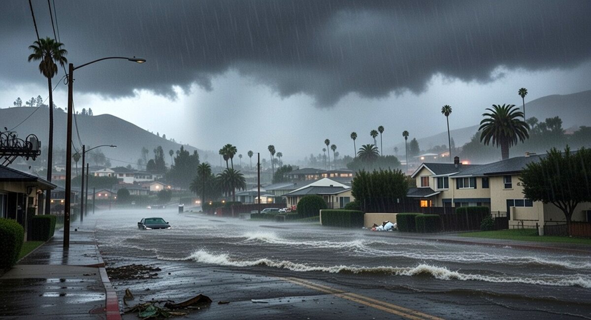
This atmospheric river — essentially a massive conveyor belt of tropical moisture streaming into the U.S. West Coast — has delivered rainfall far above seasonal norms, saturating soils that were already damp from earlier systems. Southern California is bearing the brunt, with flash flood warnings actively in effect, mud and debris flows reported, and communities urged to seek higher ground.
Why this matters:
- Atmospheric rivers are the primary drivers of California’s heavy winter precipitation. When they stall over a region, flash floods, debris flows, and river flooding can materialize rapidly — sometimes within minutes.
- The storms’ timing around Christmas amplified their impact as travel and holiday plans converged with hazardous conditions.
How Severe Is the Flood Risk Right Now?
Flash Flood Warnings Across the Region
The National Weather Service (NWS) has issued flash flood warnings for significant portions of Southern California, particularly in and around Los Angeles and Ventura counties. These warnings are not generic advisories — they reflect immediate threats to life and property due to rapidly rising water levels and runoff.
In the Los Angeles area:
- Areas like Altadena, Glendale, Santa Clarita, Burbank, and Thousand Oaks have all been placed under heightened flood risk (some under “High Risk” categories rarely used in forecasts).
- Flash Flood Warnings have been extended through multiple periods throughout Christmas Eve and into Christmas Day.
These warnings are not seasonal routine; they signal imminent danger that requires immediate public response — usually evacuation or seeking shelter on higher ground.
Southern California Under “High Risk”
The Weather Prediction Center (WPC) designated large sections of SoCal as a Level 3 or Level 4 flood threat, indicating significant probability of extreme rainfall and flooding across populated regions, including greater Los Angeles.
State of Emergency: Why It Was Declared
Facing prolonged heavy rains and escalating flood impacts, California Governor Gavin Newsom has declared a state of emergency covering multiple key counties, including Los Angeles, Orange, Riverside, San Bernardino, and San Diego. This official action unlocks state resources, expedites federal aid, and provides additional support for evacuations and disaster response efforts.
What a State of Emergency Means
- Emergency services are fully mobilized, including fire crews, law enforcement, and the California National Guard.
- Shelter operations are open for residents who need safe housing due to evacuations.
- Road closures and rescue assets are prioritized — a crucial move as flooding and mudslides compromise key transportation arteries.
This is standard emergency policy when weather events pose widespread threats — but not all community leaders declare it pre‑emptively. The broad scale here shows officials view the hazard as serious, sustained, and expansive.
Evacuations and Public Safety Actions
Mandatory and Voluntary Evacuations
As the storm progressed, both mandatory and voluntary evacuation orders went into effect — especially in areas recently impacted by wildfires. These previously burned zones are more susceptible to debris flows and mudslides, as loose soil and ash easily mobilize with heavy rain.
Evacuation zones include:
- Airport Fire burn area in Orange County (mandatory)
- Various foothill and canyon communities in Los Angeles County (voluntary to mandatory)
Officials strongly urged residents not to wait until the last minute to relocate, as conditions can deteriorate quickly — and in past storms, delays have cost lives.
Shelters and Emergency Services Activated
Local jurisdictions — including Los Angeles County — have opened emergency shelters for people whose homes are in harm’s way or who lack safe shelter.
First responders are focused on:
- Search and rescue operations
- Flood monitoring and water diversion efforts
- Road safety and traffic mitigation
What the National Weather Service Says (Official Perspective)
This isn’t just meteorologist chatter — the NWS has explicitly warned that flash flooding, mudslides, and even strong wind events are likely as the atmospheric river continues to drench the region.
Key official points:
- Flooding can occur with little to no warning — classic flash flood behavior.
- Southern California could see 3–5+ inches of rain over short periods — enough to overwhelm drainage systems.
- The hazard is not uniform — foothill and canyon zones, especially burn scar areas, remain priority threats.
Real‑Time Community Impacts
Roads Turned to Rivers
Reports from affected regions describe highways and surface streets inundated with water, leading to closures and stranding drivers. In some mountain passes, roads have been blocked by mud and debris as storm runoff surges downhill.
Rainfall Rates Exceeding Anchors
In parts of Southern California, rain gauges have logged intense rainfall rates — more than an inch per hour in some places — a level that rapidly overwhelms urban storm systems.
Local weather staffers have never seen Christmas storm rainfall totals this high in many of the impacted zones, underscoring how extraordinary this event has become.
What’s Next: Forecast and Hazards Through Christmas Day
Rain and storm impacts are expected to continue through Friday, with some regions getting additional atmospheric river pulses and others seeing lingering flooding conditions.
This means:
- Travel disruptions — both on highways and at major airports.
- Ongoing flood and mudslide risks — especially in burn zones and steep terrain.
- Potential for repeated flash flood warnings as more water falls and rivers rise.
How Residents Should Respond
From local emergency management guidance and NWS advisories:
- Avoid unnecessary travel — surface streets and freeways can become hazardous quickly.
- Heed evacuation orders immediately — don’t wait to be told again.
- Stay informed via official apps and alerts — flash flood warnings activate digital alerts in real time.
And remember: turning around at flooded roads saves lives — a mantra emergency officials repeat because too many people underestimate the power of moving water.
Editorial Insight
Having covered weather emergencies for over a decade, I can tell you this: storms of this magnitude — especially near major population centers like Los Angeles — are rare but not unprecedented. What makes this event especially hazardous is the combination of saturated soils, recent wildfire burn scars, and the holiday timing. In my experience, events like these test the resilience of infrastructure and emergency systems alike, and public compliance with evacuation orders often makes the difference between a close call and catastrophe.
Summary
- A major atmospheric river storm is pummeling California during Christmas 2025, with particularly severe impacts in Southern California.
- Flash flood warnings and high flood risk classifications are currently in effect across Los Angeles and surrounding counties.
- State of emergency declarations and evacuation orders demonstrate the seriousness of the threat.
- Residents are urged to follow official guidance, avoid flood waters, and stay off roads if possible.
If you’re in an affected community, use real‑time tools (local NWS alerts, county emergency notification systems) to track shifting conditions — and reconsider any travel plans until the storm passes safely.