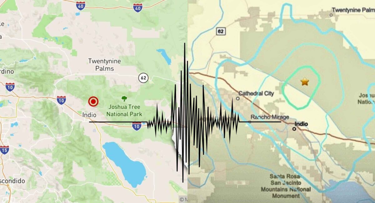
A magnitude 4.9 earthquake struck near Indio Hills in Riverside County, Southern California, at about 5:56 p.m. PT on Monday, January 19, 2026, according to the U.S. Geological Survey (USGS). The quake — centered roughly **12 miles northeast of Indio — was widely felt across the **Coachella Valley, Palm Springs area, Riverside County and parts of San Diego County. Multiple aftershocks ranging from about 2.9 to 3.4 magnitude followed the main temblor. No major damage or injuries have been confirmed as of the latest official reports, but residents reported noticeable shaking.
What Happened — Earthquake Details
At approximately 5:56 p.m. Pacific Time, seismic stations recorded a magnitude 4.9 earthquake near Indio Hills / Coachella Valley in Riverside County, California, with a depth of roughly 1.8–3.0 kilometers below the surface — a shallow event that tends to cause more perceptible shaking at the ground level.
Magnitude and Epicenter
- Magnitude: 4.9, as per USGS preliminary and reviewed data.
- Location: About 12 miles (19 km) northeast of Indio Hills, in Riverside County.
- Depth: Around 1.8–3 km (shallow).
- Time: 5:56 p.m. PST, Monday, Jan. 19, 2026.
Several seismic stations initially logged preliminary values with slight variation (4.6 – 5.1) before the USGS consolidated the measurement to 4.9 magnitude, which is common as data from additional detectors are integrated.
Where the Shaking Was Felt
Due to its shallow depth and proximity to populated areas, the quake was widely felt throughout Southern California:
- Coachella Valley & Palm Springs: Residents reported moderate shaking, with lights and furniture moving.
- Riverside County: Tremors reached portions of Riverside and surrounding desert communities.
- San Diego County: People in northern San Diego County (e.g., Murrieta, Temecula, and even parts of San Diego) felt the quake.
- Other Southern California areas: Social accounts corroborate shaking noticeable in San Diego’s inland neighborhoods like University Heights and Kearny Mesa, with communities across the region commenting on brief jolts and rolling motion.
This widespread feel is consistent with moderate, shallow quakes in Southern California, where dense population and complex local geology transmit seismic waves efficiently over a broad area.
Aftershocks and Continued Activity
Following the main 4.9 event, a series of aftershocks was observed within minutes:
- Recorded aftershocks ranged from about 2.9 to 3.4 magnitude, according to USGS and local seismic data.
- Aftershocks are typical after moderate earthquakes, as the crust adjusts to redistributed stress along the fault zone.
Seismologists note that aftershocks can continue for hours, days or even longer after a primary quake, and while most are smaller, some can approach the magnitude of the original event, particularly near active fault structures.
Living with Earthquakes in Southern California
Why California Quakes Happen
Southern California sits atop a network of major faults that are part of the boundary between the Pacific and North American tectonic plates. The best-known of these is the San Andreas Fault, but others such as the San Jacinto Fault Zone and related fault strands crisscross the region, accumulating strain and periodically releasing it as earthquakes.
Even relatively moderate quakes like today’s 4.9 are part of this ongoing tectonic activity and are not uncommon. California averages dozens of quakes in the 4.0–5.0 range each year as part of its normal seismicity patterns.
What Residents Felt
Personal reports from residents and seismic communities paint a picture of varied experiences:
- Many Southern Californians reported a sharp jolt followed by a rolling sensation, typical of shallow temblors.
- In areas farther from the epicenter, such as parts of San Diego, some felt a quick, less intense movement, while others barely noticed it.
- Some phone users received ShakeAlert early-warning notifications just seconds before shaking began, showcasing the expanding reach of early-warning systems.
Damage, Injuries, and Official Reports
As of the latest updates from emergency services and USGS:
- No serious damage or structural collapse has been reported.
- No confirmed injuries linked to the quake have been declared.
- Local authorities in Palm Springs and Riverside County confirmed initial inspections found no significant issues.
Moderate quakes in the 4.5–5.0 range can move unsecured items, cause small cracks in plaster or knock objects off shelves, but they rarely produce large-scale destruction, especially in areas with modern building codes.
Earthquake Preparedness — What You Can Do Now
Even moderate quakes underscore the value of being ready. Here’s a practical checklist based on emergency management guidance:
1. Drop, Cover, and Hold On
If you feel shaking, get down on your hands and knees, cover your head and neck (ideally under sturdy furniture), and hold on until the tremors cease.
2. Check for Hazards Post-Quake
Look for gas smells, water line breaks, or electrical sparks. If you suspect a gas leak, evacuate and notify authorities immediately.
3. Prepare an Emergency Kit
Include water, food, a flashlight, first-aid supplies and communication tools.
4. Know Your Zone
Understanding proximity to major fault zones like the San Andreas and San Jacinto systems helps in long-term risk awareness.
These steps don’t eliminate earthquake risk, but they significantly minimize harm to people and property in quake-prone regions.
Conclusion — A Reminder of California’s Seismic Reality
The magnitude 4.9 earthquake near Indio Hills on January 19, 2026, stands as the largest seismic event in Southern California so far this year, felt from Palm Springs to San Diego and beyond. Its shallow depth amplified its perceptibility, sending palpable jolts through residential and desert communities alike. While no major damage has been documented, the earthquake and its subsequent aftershocks serve as a prompt reminder of California’s ever-present seismic risk.
Residents across Southern California — whether in the Coachella Valley, Riverside, or San Diego areas — should stay alert for additional aftershocks, maintain preparedness routines, and pay attention to verified updates from agencies like the USGS and local emergency services as more data becomes available.