The National Weather Service (NWS) and multiple major forecasting agencies are warning that Winter Storm Fern may bring significant snow, sleet, freezing rain, and ice across a massive swath of the United States this weekend (January 23–25, 2026), from Texas and the Southern Plains through the Southeast and up the East Coast. This system could produce heavy snow in parts of the Mid-Atlantic and Northeast, devastating ice accumulations in the South, and hazardous travel conditions nationwide, as a powerful arctic air mass collides with abundant Gulf and Atlantic moisture.
National Weather Service Forecast – What’s Expected
Meteorologists describe the coming system — already named Winter Storm Fern in forecasts — as one of the broadest winter storm setups so far this season, with impacts spanning hundreds of miles. The NWS has issued alerts and watches ahead of the expected storm.
Snow, Ice, and Sleet — The Triple Threat
The storm’s complexity arises from multiple forms of precipitation that will likely unfold as follows:
- Friday into Saturday: Snow and sleet begin across Texas and the Southern Plains, mixing with rain before temperatures plunge into freezing levels.
- Saturday into Sunday: As cold air deepens and the storm tracks east, precipitation will shift to freezing rain and sleet in the Southeast and coastal areas, with heavy snow farther north and west where temperatures remain below freezing.
- Sunday: Snow and ice will slowly taper off from west to east, but hazardous travel conditions may persist into early next week.
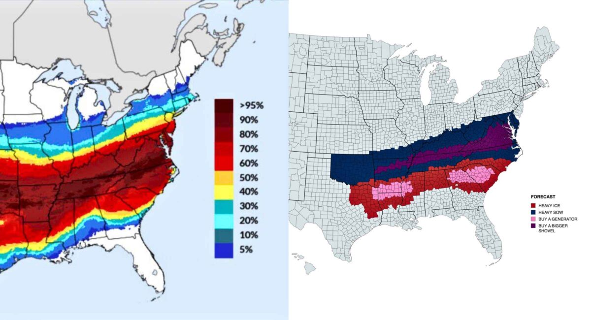
The National Weather Service warns of “great swaths of heavy snow, sleet, and treacherous freezing rain” — and says even moderate ice accumulations (around a half-inch) can cause catastrophic impacts, including power outages and downed tree limbs.
Atmospheric Setup — Why This Storm Is Significant
This weekend’s storm isn’t just another cold front. It’s the result of three key ingredients:
- Arctic Air Intrusion: A deep polar vortex will plunge well into the United States from Canada, driving temperatures far below average for late January.
- Moisture Plume from the Gulf: A corridor of moisture flowing northward — often referred to by meteorologists as an atmospheric river — will feed the system, providing the fuel for heavy precipitation.
- Clash Zone: Where the cold Arctic air meets Gulf and Atlantic moisture, heavy snow and dangerous ice coexist, increasing the storm’s impact potential.
This setup means areas unaccustomed to major winter storms — particularly parts of the Deep South and Southeast — could see significant ice and snow. Residents in the South are being urged to prepare early, as even a few inches of ice can affect power, roads, and daily life.
Geographic Outlook — Who’s In the Storm’s Path
Southern Plains and Deep South
- Texas & Oklahoma: Rain will change over to freezing rain and sleet by Friday night, with snow and icy roads expected Saturday into the weekend.
- Louisiana, Mississippi, Alabama: A dangerous mix of precipitation and sub-freezing temperatures could make travel nearly impossible.
- Georgia & South Carolina: Ice accumulations and heavy snow are possible, particularly north of Interstate 20.
Southeast and Mid-Atlantic
- Atlanta, Raleigh, Charlotte: Freezing rain is likely to transition to snow as temperatures drop.
- Washington, D.C., Baltimore, Philadelphia: Snow could begin late Saturday, with accumulation possible into Sunday — though exact totals remain uncertain as models continue to adjust.
Northeast
- New York City, New England: Snow is possible especially north and west of I-95, with higher elevations expected to see the greatest accumulations.
- Mid-Atlantic Corridor: Heavy snow and prolonged cold could affect travel on major interstates and into early next week.
Forecast confidence remains medium-high for winter storm impacts, but the exact track and precipitation type (snow vs. ice) will become clearer with high-resolution models as the storm draws nearer.
Potential Impacts of Winter Storm Fern
Travel Disruptions
With snow and ice accumulating across major transportation corridors, authorities are warning of:
- Road closures and hazardous driving conditions particularly in the South where winter equipment is less common.
- Flight delays and cancellations at key airports from Dallas to Atlanta to Washington, D.C.
- Slippery sidewalks and bridges, as freezing rain can coat elevated surfaces quickly.
Power Outages
Ice accumulations weighing down tree limbs and power lines are a major concern. Even a half-inch of ice can cause damage to infrastructure, leading to localized or widespread outages.
Public Safety Concerns
- Extended cold after the storm could keep ice on surfaces for days, prolonging dangerous conditions.
- Vulnerable populations — such as the elderly and those without adequate heating — are particularly at risk.
Officials are urging residents to prepare now: stock up on essentials, ensure heating systems are functioning, and stay tuned to official NWS forecasts for updates.
How to Prepare for Snow This Weekend
Here’s a practical checklist that many emergency managers recommend (and the National Weather Service endorses similar guidance):
1. Monitor Local Forecasts:
Weather conditions can change rapidly; check NWS updates regularly.
2. Prepare an Emergency Kit:
Include nonperishable food, water, flashlights, batteries, and medical supplies for at least 72 hours.
3. Protect Plumbing:
Insulate pipes and disconnect outdoor hoses to prevent freezing and bursting.
4. Plan Travel Carefully:
If you must travel, allow extra time, carry a winter survival kit in your vehicle, and avoid unnecessary trips during peak storm hours.
5. Check on Neighbors:
Especially seniors or those with mobility issues — be sure they have heat, food, and reliable communication.
Being proactive can reduce storm-related stress and protect family and property.
Why This Storm Matters
Winter Storm Fern isn’t just another cold-weather event — it’s the result of a rare atmospheric pattern that brings an arctic blast deep into the South at the same time as moisture surges northward from the Gulf of Mexico. This combination sets the stage for heavy snow, widespread ice, and dangerous conditions over a huge area — from Texas through the Carolinas and up the East Coast.
That kind of broad threat is unusual and challenges emergency services across multiple states simultaneously — particularly in regions without strong winter storm infrastructure. Staying informed and prepared is essential as the situation evolves.
Conclusion: Stay Alert — Snow and Ice This Weekend
The National Weather Service sees increasing potential for a significant winter storm this weekend as Winter Storm Fern gathers strength. Heavy snow, sleet, and damaging ice could impact millions of Americans from Texas to the Eastern Seaboard, making travel treacherous and heightening the risk of power outages. While exact details on snowfall totals and ice depths will become clearer later in the week, early preparation — especially in vulnerable regions — is crucial. Residents should monitor official forecasts and heed local warnings as the storm approaches.